TimelapseLab's Cutting-Edge Satellite Imaging
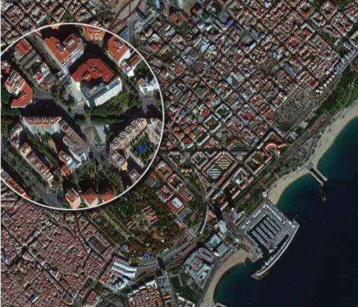
In collaboration with the main satellite photos providers, TimelapseLab offers to its client high-definition satellite images in order to monitor in real-time the construction site, to view maps in details and to plan future actions even from afar.
This service, through satellite pictures, allows you to observe the evolution of the location and the comparison between the most recent photos and the past ones.
Talk to our experts of satellite images
We will help you find the best solution for your needs.
Tel: +39 0376 1811478 – Mail: [email protected]
USE
Advantages

Analysis
Usage of satellite images in the timing sequence to analyze the transformation of the area of interest.

High resolution satellite photos
High resolution satellite photos. Split screen option (mosaic) in case of shooting from two or more devices.

Global Coverage
Define your area of interest without geographic limits.

Updated satellite images
Timelapse Lab provides you with updated satellite images in collaboration with the best providers of satellite images.

Accuracy
See beyond the clouds and smoke; distinction between buildings and agricultural area.
Who we serve
At TimelapseLab, we cater to a wide range of clients, including:
- Chief Executive Officers (CEOs), managers
- Marketing and communication professionals
- Project management teams (such as engineers, architects, and surveyors on-site)
- Contracting directors and technical offices for improvements in tender competitions
- Certifying bodies for LEED certification
We collaborate with major companies like Fincantieri, Enel, Siemens, Eni, Maersk, and many others. We ensure them high-level collaboration and offer sophisticated tools that allow real-time monitoring of construction site developments, detailed analysis of plots, and future intervention planning anywhere in the world.
Our satellite images serve as invaluable tools for understanding environmental, urban, and infrastructural changes over time, enabling precise comparisons between current and past situations.
By choosing our solutions, companies can ensure better planning and greater operational efficiency for their projects.
How the satellite images capturing works?
The service compares data of the main satellites in order to provide high-quality updated images, according to the different needs.
It also gives the opportunity to view in sequence the satellite images of the same location in different periods of time such as days, weeks and months in order to have an overview of all the changes that have occurred in that period.
The satellite image offers a unique and unprecedented point of view, creating a sense of wonder.
Satellite photos purpose
The access to the past satellite photos is useful to analyze the evolution of a specific area over time. The analysis of the timeline of the satellite images can be a valid support in the prediction of all the possible future events.
Customers
This service could be useful for several activities:
- Design and construction of infrastructures;
- Monitoring of surfaces and for the current project activity :
- Opportunity to control the competitors’ activity;
- Detection of illegal buildings;
- Maintenance of cadastral maps;
- Agricultural controls;
- Control of sea areas;
Other timelapse services
Are you fully convinced that satellite imagery is right for you? Among our services, we offer even more specific solutions tailored to your needs, including:
- Aerial site footage: through drone video production, we can provide visually impactful aerial footage that further enriches the timelapse. Drone videos are excellent content for successful marketing campaigns. Go to Aerial site footage service to disocver more.
- Remote Monitoring: Remote monitoring technology offers an efficient method for overseeing long-term projects. This system, based on photographs taken at regular intervals, allows for constant and detailed control of the construction site of interest, without the need for physical presence on site. Go to remote monitoring services.
Discover more about our services and transform the way you look at your project.
Companies that trust us
What are the uses of time lapse videos for construction sites?
Thanks to time lapse videos one can monitor the progress of their construction site and create impactful content to promote their project.
What is the quality of the images taken by Timelapselab devices?
Our industrial-grade devices have high-quality lenses and can create and export 4K time lapse videos.
Can Timelapselab devices resist harsh weather conditions?
Yes. Our devices have an ultra resistant aluminum and steel case and they are designed to resist in the harshest weather conditions like strong wind, rain, snow or sand. Furthermore, the lenses have an auto cleaning system to avoid ruining the images with dust or debris.
Count on us
Monitor your construction site wherever you are with Timelapselab
Mail: [email protected]
Tel: +39 0376 1811478
+39 3478247830


© 2022 VLAB s.r.l. — Via Solferino e San Martino 14, 46100 Mantova — VAT: IT02588410205
Viale Vittorio Veneto 6, 20124, Milano (MI)
TimelapseLab® is a registred mark of VLAB S.R.L
Innovative start-up lodged in accordance with Article 4 subsection 10 bis of Decree-Law of 24 January 2015, n. 3
Phone +39 3351375089 / +39 03761811478
Email [email protected]
Stakeholder
Timelapse FAQ
Services
Support
®Timelapselab – All right reserved